Friday, July 26, 2024

Fire Activity 7/26/2024

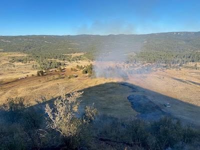
 Cottonwood Springs Fire

Time Reported:  7/26/2024 6:03 pm

  • Size: .10 acre
  • Location: Chaffee County, Salida Ranger District, 6 miles W of Buena Vista,
  • Jurisdiction: US Forest Service
  • Resources: 1 Engine Crew
  • Containment: 
  • Controlled: 
  • Structures Threatened: None
  • Evacuation: None
  • Closures: None
  • Cause: Lighting
  • Fuels: Pinon Pine, Juniper
  • #CottonwoodSpringsFire_CO

  • Map

Tuesday, July 23, 2024

Fire Activity 7/23/2024

Metz Fire

Time Reported:  7/23/2024 4:01 pm

  • Size: .10 acre
  • Location: Douglas County, Pikes Peak Ranger District, 10 Miles NW of Monument, CO
  • Jurisdiction: US Forest Service
  • Resources: USFS small hand crew
  • Containment:  100% 7/24/24 12pm
  • Controlled: 7/25/24 
  • Structures Threatened: None
  • Evacuation: None
  • Closures: None
  • Cause: Lightning
  • Fuels: Mixed conifer, duff
  • #MetzFire_CO


Update 7/24/2024 12 pm: The Metz fire has been contained. Firefighters will remain on scene mopping up hotspots on the fire. 

Update 7/24/2024 8:30am: The helicopters were successful limiting the spread of the fire yesterday evening. Firefighters will be hiking in again this morning to continue to build fireline around the fire. 

Initial update: Fire is located in a remote area of the Pike National Forest SW of Larkspur. Resources on scene are utilizing helicopters to drop water on the fire to limit the spread of the fire.

Lightning strike tree found on 7/23/24

Smoldering fire found by firefighters. Photo taken on 7/23/24


 Dunn Fire

Time Reported:  7/23/2024 13:22 pm

  • Size: .10 acre
  • Location: Lake County, Leadville Ranger District, 4 miles West of Leadville, CO near Turquoise Lake
  • Jurisdiction: US Forest Service
  • Resources: USFS engine and county resources
  • Containment:  100% 7/23/24 @ 4:13pm for .10
  • Controlled: 7/23/24 @ 4:13pm for .10
  • Structures Threatened: None
  • Evacuation: None
  • Closures: None
  • Cause: Unknown
  • Fuels: duff
  • #DunnFire_CO

  • Map

Sunday, July 21, 2024

Fire Activity 7/21/2024

  Limbaugh Fire

Time Reported:  7/21/2024 12:47 pm

  • Size: .10 acre
  • Location: El Paso County, Pikes Peak Ranger District, 4.82 miles SW of Monument, in Limbaugh Canyon
  • Jurisdiction: US Forest Service
  • Resources: 1 squad hand crew
  • Containment: 
  • Controlled: 7/22/2024 at 10:45am for 0.10 acre
  • Structures Threatened: None
  • Evacuation: None
  • Closures: None
  • Cause: Human caused, campfire
  • Fuels: duff, pine needles
  • #LimbaughFire_CO

  • Map

Friday, July 19, 2024

Fire Activity 7/19/2024

Jones Gulch Fire

Time Reported:  7/19/2024 1:23pm

  • Size: 1 acre
  • Location: Custer County. San Carlos RD. 11.5 mi. SE of Westcliffe, CO
  • Jurisdiction: US Forest Service
  • Resources: 1 USFS  Engine, Custer County Resources, Wet Mtn
  • Containment: 100%  7/19/24  at 11:00 am for 1 acre
  • Controlled: 7/21/2024 11:00 am at 1 acre
  • Structures Threatened: None
  • Evacuation: None
  • Closures: None
  • Cause: Lightning
  • Fuels: mixed conifer, ground fuels, duff
  • #JonesGulchFire_CO

Update 7/21/2024 11:30 am: Firefighters are back on the fire and have gained full  control 7/21/2024 11:00 am at 1 acre and will continue putting out hotshots within the interior of the fire. 

Update 7/20/2024 6:30 pm:  Firefighters are off the fire for the day and will return in the morning to continue with the suppression efforts.

Update 7/20/2024 10:00 am:  Firefighters are back on the fire and have gained full  containment.  Fire did not increase in size over night. 


The Jones Gulch fire is currently receiving rain. Firefighters have hiked out and will return to the fire after the rain has passed. 

Map:


Thursday, July 18, 2024

Fire Activity 7/18/2024

 Soldier Mountain Fire

Time Reported:  7/18/2024 5:24pm

  • Size: .10 acre
  • Location: Teller County, Pikes Peak Ranger District, Near Rampart Range Road and Forest Road 300U
  • Jurisdiction: US Forest Service
  • Resources: 1 small hand crew
  • Containment: 100% 7/18 6:51PM
  • Controlled: 
  • Structures Threatened: None
  • Evacuation: None
  • Closures: None
  • Cause: Human caused
  • Fuels: duff, pine needles
  • #SoldierMtnFire_CO

Wednesday, July 17, 2024

Fire Activity 7/17/2024

   Russell Fire

Time Reported:  7/17/2024 11:03pm

  • Size: .10 acre
  • Location: Douglas County, South Platte Ranger District, near Waterton Canyon, CO 
  • Jurisdiction: US Forest Service
  • Resources: US Forest Service resources
  • Containment: 100% on 7/17/2024 at 2:49pm
  • Controlled: on 7/17/2024 at 2:49pm
  • Structures Threatened: None
  • Evacuation: None
  • Closures: None
  • Cause: Abandoned, escaped campfire
  • Fuels: duff, logs
  • #RussellFire_CO

Map:

Monday, July 15, 2024

Fire Activity 7/14/2024

  Camp 6 Fire

Time Reported:  7/14/2024 7:21pm

  • Size: .10 acre
  • Location: Jefferson County, South Platte Ranger District, 3 miles Southwest of Pine, CO 
  • Jurisdiction: US Forest Service
  • Resources: US Forest Service resources
  • Containment: 100% on 7/15/2024 at 12:10pm
  • Controlled: on 7/15/2024 at 12:16pm
  • Structures Threatened: None
  • Evacuation: None
  • Closures: None
  • Cause: escaped campfire
  • Fuels: grass
  • #Camp6Fire_CO
Map: 


  Turner Gulch Fire

Time Reported:  7/14/2024 3:11pm

  • Size: .10 acre
  • Location: Park County, South Park Ranger District, South of Tarryall Reservoir , CO 
  • Jurisdiction: US Forest Service
  • Resources: US Forest Service resources
  • Containment: 100% on 7/14/2024 at 3:15pm
  • Controlled: on 7/14/2024 at 3:15pm
  • Structures Threatened: None
  • Evacuation: None
  • Closures: None
  • Cause: escaped campfire
  • Fuels: duff, logs
  • #TurnerGulchFire_CO

Map:

Sunday, July 14, 2024

Fire Activity 7/13/2024

   Elbert Lake Fire

Time Reported:  7/13/2024 3:45pm

  • Size: .10 acre
  • Location: Lake County, Leadville Ranger District, 10 Miles South of Leadville, CO 
  • Jurisdiction: US Forest Service
  • Resources: US Forest Service & Lake County resources
  • Containment: 100% on 7/13/2024 at 5:30pm
  • Controlled: 7/13/2024 at 5:30pm
  • Structures Threatened: None
  • Evacuation: None
  • Closures: None
  • Cause: unattended campfire
  • Fuels: duff, logs
  • #ElbertLakeFire_CO
Initial Report: Resources from Interlaken Fire as well as Lake County respond to a smoke check, campers belongings present but no campers were in the area. Resources extinguished the 5'x7' unattended campfire. The Elbert Lake fire was declared contained, controlled and out at 5:30pm on 7/13/2024.

Map:

Thursday, July 11, 2024

Fire Activity 7/11/2024

  Raspberry Mt Trail Fire

Time Reported:  7/11/2024 7:36am

  • Size: .10 acre
  • Location: El Paso County, Pikes Peak Ranger District, 4 Miles Southwest of Monument, CO 
  • Jurisdiction: US Forest Service
  • Resources: US Forest Service engines, Palmer Lake & Monument firefighters 
  • Containment: 100% on 7/11/2024 at 4:30pm
  • Controlled: 7/15/24 at 8:35am for .10 acre
  • Structures Threatened: None
  • Evacuation: None
  • Closures: None
  • Cause: Unknown; under investigation
  • Fuels: oak brush, ponderosa pine, & mix conifer
  • #RaspberryMtTrailFire_CO
Update 7/11/24 3:40pm: All resources on the Raspberry Mt Trail Fire have been released except 1 engine. At 2:22pm the fire was reported 75% contained. Mop up efforts continue.

Update 7/11/24 2:00pm: Firefighters are utilizing the hose lays to continue mopping up the fire. As of 12:06pm, today, the Raspberry Mt Trail Fire was 50% contained. Fire remains .10 acre.

Initial Response: Firefighters from the US Forest Service, Monument & Palmer Lake have responded to the Raspberry Mt Trail Fire. All forward progression has been stopped on the fire and crews will continue to secure fire lines and mop the fire up. 

Map:

Monday, July 8, 2024

Fire Activity 7/7/2024

   Davis Meadow Fire

Time Reported:  7/07/2024 6:00 pm

  • Size: .10 acre
  • Location: Chaffee County, Salida Ranger District, 6 Miles Southwest of Buena Vista, CO 
  • Jurisdiction: US Forest Service
  • Resources: US Forest Service engine
  • Containment: 100% 7/8/24 at 4:00 pm for .10 acre.
  • Controlled: 7/11/2024 at 2:00pm for .10 acre.
  • Structures Threatened: None
  • Evacuation: None
  • Closures: None
  • Cause: lightning
  • Fuels: Lodge pole, Dough fir
  • #DavisMeadowFire_CO

 Update 7/9/24 2:30pm: Salida engine confirmed Davis Meadow Fire was contained on 7/8/24 at 4:00pm 

 Update 7/8/24 6:00pm: The engine crew is hiking off the fire and plan on returning tomorrow to ensure no smoke or heat is present within the fires perimeter. 

 Update 7/8/24 4:00pm: Name correction from David Meadows to Davis Meadows Fire. Resources are still on scene working on mopping up the fire. Fire remains .10 acre.

Initial Report: 7/8/24 12:30pm - Forest Service engine has arrived on scene of the Davis Meadow Fire that was reported late last night. The fire is .10 acre with low spread potential. Engine crew members are working to contain the fire.

Map:

Friday, July 5, 2024

Fire Activity 7/5/2024

  Messenger Fire

Time Reported:  7/05/2024 11:52 am

  • Size: .10 acre
  • Location: Park County, South Park Ranger District, 5 Miles Southwest of Lake George, CO
  • Jurisdiction: US Forest Service
  • Resources: US Forest Service resources: hand crew
  • Containment: 100% Contained at 12:00pm 7/5/24
  • Controlled: Fire declared controlled and out at 12:27pm 7/5/24
  • Structures Threatened: None
  • Evacuation: None
  • Closures: None
  • Cause: abandoned, escaped campfire
  • Fuels: Logs, grass, duff
  • #MessengerFire_CO
Crews have found and abandoned, escaped campfire in the Springer Gulch area. They have extinguished and contained the abandoned campfire. 

Map:

Wednesday, July 3, 2024

Fire Activity 7/03/2024

 Scraggy View Fire

Time Reported:  7/03/2024 11:59 am

  • Size: .25 acre
  • Location: Jefferson County, South Platte Ranger District, 5 Miles Southeast of Buffalo Creek, CO
  • Jurisdiction: US Forest Service
  • Resources: US Forest Service resources: 2 engines & a handcrew 
  • Containment100% contained on 7/3/24 at 7:00pm
  • Controlled: 7/4/24 at 2:05pm for .25 acre 
  • Structures Threatened: None
  • Evacuation: None
  • Closures: None
  • Cause: unknown
  • Fuels: Grass, Juniper & Ponderosa Pine
  • #ScraggyViewFire_CO

Update: 7/4/24 2:00pm - Resources declared the fire 100% contained as of 7:00pm 7/3/24. Today crews made their way into the #ScraggyViewFire_CO and have confirmed that all fire lines held. Little to no smoke showing within the fire perimeter. 

Update: 7/3/24 7:40pm - All resources on the #ScraggyViewFire_CO have come off the fire line. They plan on reengaging, tomorrow 7/4/24. The helicopter and handcrew will continue mopping up the .25 acre fire and securing its edge.

Update: 7/3/24 5:00pm - Crews have made it on scene of the #ScraggyViewFire_CO and are working with the helicopter doing bucket drops to suppress the fire. The fire remains .25 acre and is creeping with a low rate of spread potential.

Initial Report: The helicopter is currently doing bucket drops over the fire.US Forest Service engines & module crews are looking to gain access into the fire as they have to cross the South Platte River to get to it. 

Map:

Monday, July 1, 2024

Fire Activity 7/1/2024


Round Mountain Fire

Time Reported:  7/01/2024 12:19 pm

  • Size: .10 acre
  • Location: Park County, South Park RD, 7 Miles Northwest of Florissant, CO
  • Jurisdiction: US Forest Service
  • Resources: US Forest Service module
  • Containment: 100% Contained @3:30pm at .10 acre
  • Controlled:  7/3/24 @12:05pm .10 acre
  • Structures Threatened: None
  • Evacuation: None
  • Closures: None
  • Cause: Lightning
  • Fuels: Grass & Ponderosa Pine
  • #RoundMountainFire_CO
7/3/2024 12:05 pm Update: Crews have checked the Round Mountain Fire and have declared it controlled at 12:05pm on 7/3/24

7/01/2024 6:35pm update: The fire was contained at 3:30pm and crews are hiking out of the fire. The crews will hike back in tomorrow to check for any hotspots that might remain. 

7/01/2024 Initial Report: Crews have hiked into the fire and are actively engaging in suppressing it. The fire is creeping and has a low rate of spread.


#RoundMountainFire_CO Contained @3:30p.m. for .10 acre. The picture shows the progression of the fire line crews constructed to establish containment.


Map: